Trail Walking Les Allues - du refuge du Grand plan à Mottaret  - Photo

du refuge du Grand plan à Mottaret

 bymarc26
bymarc26

User

© OpenStreetMap contributors
Length
Length
15.5 km
Max alt
Max alt
2903 m
Uphill gradient
Uphill gradient
408 m
Km-Effort
Km-Effort  
24 km
Min alt
Min alt
1684 m
Downhill gradient
Downhill gradient
1243 m
Boucle
Boucle
No
Creation date :
2023-08-10 08:32:55.31
Updated on :
2023-08-10 15:47:07.22

(0 Reviews)

Walking
Walking
4h35
Difficulty : Very difficult

Scan this QR Code to open this trail in the SityTrail application

FREE GPS app for hiking

Logo SityTrail SityTrail

IGN / Geographical institutes

Download SityTrail from the App Store Download SityTrail from Google Play

Logo SityTrail SityTrail World

The world is yours!

Download SityTrail from the App Store Download SityTrail from Google Play Download SityTrail on Huawei AppGallery

About

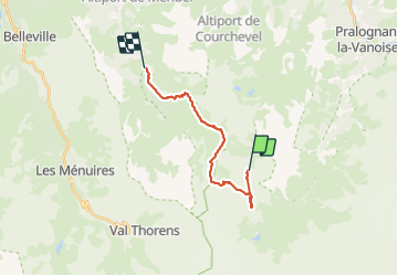
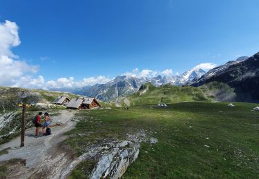
Trail Walking of 15.5 km to be discovered at Auvergne-Rhône-Alpes, Savoy, Les Allues. This trail is proposed by bymarc26.

Description

oublié de démarrer le gps
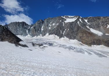
passage par col de Chantougr
dénivelé réel 913  et 1482-
temps 8h

Elevation profile

Photos

Positioning

Country:
France
Region :
Auvergne-Rhône-Alpes
Department/Province :
Savoy
Municipality :
Les Allues
Location:
Unknown
Start:(UTM)
315657 ; 5021696 (32T) N.

Trails nearby

Trail Walking Les Belleville - FR - VAL THORENS - Circuit des lacs de Val-Thorens - Photo
Walking
pecha

Walking

Very easy
(1)
Les Belleville, Auvergne-Rhône-Alpes, Savoy, France
6.2 km | 8.6 km-effort
4h 15min
Yes
Trail Walking Pralognan-la-Vanoise - Pralognan - Les Prioux  Lac de Chalet Clou - Photo
Walking
countryjack

Walking

Easy
(3)
Pralognan-la-Vanoise, Auvergne-Rhône-Alpes, Savoy, France
11 km | 19.3 km-effort
4h 41min
Yes
Trail Walking Pralognan-la-Vanoise - Dôme de Polset - Photo
Walking
GUIDE
amiral13

Walking

Very difficult
Pralognan-la-Vanoise, Auvergne-Rhône-Alpes, Savoy, France
12 km | 27 km-effort
8h 41min
Yes
Trail Walking Pralognan-la-Vanoise - col d'Aussois et pointe de l'Observatoire - Photo
Walking
GUIDE
amiral13

Walking

Difficult
Pralognan-la-Vanoise, Auvergne-Rhône-Alpes, Savoy, France
17 km | 34 km-effort
9h 29min
Yes
Trail Walking Pralognan-la-Vanoise - le refuge de La Valette (traversée) - Photo
Walking
GUIDE
amiral13

Walking

Difficult
Pralognan-la-Vanoise, Auvergne-Rhône-Alpes, Savoy, France
13.7 km | 29 km-effort
6h 41min
No
Trail Walking Pralognan-la-Vanoise - Le Petit Mont Blanc - Photo
Walking
GUIDE
amiral13

Walking

Medium
Pralognan-la-Vanoise, Auvergne-Rhône-Alpes, Savoy, France
11.7 km | 25 km-effort
5h 8min
Yes
Trail Walking Pralognan-la-Vanoise - J2:Refuge de Péclet Polset et le lac Blanc . - Photo
Walking
rafa77

Walking

Medium
(1)
Pralognan-la-Vanoise, Auvergne-Rhône-Alpes, Savoy, France
8 km | 15.4 km-effort
Unknown
No
Trail Walking Les Allues - Col du Souffre et Lacs Mont-Coua - Photo
Walking
tracegps

Walking

Difficult
(1)
Les Allues, Auvergne-Rhône-Alpes, Savoy, France
25 km | 41 km-effort
7h 0min
Yes
Trail Walking Pralognan-la-Vanoise - Col rouge - Photo
Walking
waesberghe

Walking

Difficult
Pralognan-la-Vanoise, Auvergne-Rhône-Alpes, Savoy, France
14.9 km | 28 km-effort
4h 11min
Yes


Close
My subscriptions